2018年11月23日 星期五

奇洛埃島不願和智利一體化

奇洛埃島不願和智利一體化 

留尼汪新的海旁大道

圖文轉載自:  https://www.roadtraffic-technology.com/projects/reunion-island-new-coastal-road


The new coastal road or Nouvelle Route du Littoral (NRL) is being developed to replace the existing Reunion Island coastal highway, also known as the Route du Littoral or the RN1. It is touted 使為人所知to be France’s most expensive road project.

The new road will connect the two main cities of Reunion Island, namely Saint-Denis and La Possession.

The project is aimed at providing a safer and more reliable road connection between the two cities. The Conseil Régional de la Réunion is the public authority in charge of the project.

The construction of the project began by the end of 2013 and the entire road is expected to be ready by 2020. The project is estimated to cost €1.66bn ($1.9bn), of which the cost of the viaduct 高架橋  will be €715m ($832m).

The new La Nouvelle Route du Littoral coastal highway is expected to create approximately 18,700 jobs during its construction phase.

New Coastal Road project details

The new coastal road will be 12.5km-long and comprise three main segments, including a 5.4km-long coastal viaduct and two causeways 棧橋;堤道 (an interchange and a La Grande Chaloupe-La Possession causeway).

The 5.4km-long viaduct is being constructed along the coastline from Saint-Denis to La Grande Chaloupe. It is being constructed by VINCI Construction, Dodin Campenon Bernard, Bouygues Travaux Publics and Demathieu & Bard.

“The construction of the project began by the end of 2013 and the entire road is expected to be ready by 2020.”

The viaduct will stand between 20m and 30m above sea level and be located 70 away from the coast. The elevated highway will be 30m-wide with a dual three-lane configuration capable of accommodating buses, cars, pedestrians and bicycles.

The 3.6km-long causeway between La Grande Chaloupe and La Possession will be a dual three-lane causeway. The La Possession interchange is expected to form the other part of the new link road. The causeway will be developed by a consortium led by GTOI (a subsidiary of Colas) and includes VINCI Construction subsidiary SBTPC and VINCI Construction Terrassement.

Construction details

All the components required for the project are being pre-fabricated on land to avoid tides and minimise work at sea. Two production sites were set up in the harbour zone for prefabricating piers and segments.

Approximately 48 pre-fabricated piers were transported to the construction site using a large barge. Seven segments which form the deck portion over each pier were transported using a barge and installed along with the pier heads. Each segment weighs 2,400t. The 1,386 continuous segments which form the rest of the deck portion over the viaducts were installed using a 278m launch beam.
Two Potain MD 485 B M20s, two MDT 368 As, an MD 560 B, a Potain K5/50C, a Manitowoc 12000E-1 crawler crane, seven Grove all-terrain cranes and two Grove rough-terrain cranes are being deployed in the construction of Reunion Island new coastal road.

Contractors involved in New Coastal Road

The engineering, procurement, construction and management (EPCM) contract for the new coastal highway project was awarded to EGIS. The contract also covered the structural designs for the road.

DHI was subcontracted by EGIS to carry out the physical hydraulic model tests required to support the structures.

The other main contractors involved in the main construction works of the highway project are Colas and VINCI Construction.

CHRYSO provided environmental exposure class concrete, which offers the durability guarantee of 120 years minimum through its EnviroMix® approach, for the project.

The 16 cranes being used for the project were supplied by contractors Vinci Construction Grands Projects, Bouygues TP and Grues Levages Investissements (GLI).

Engen was awarded a €0.96m contract to provide fuel for the mega-construction project. The rock and aggregate required for the project are being provided by Comarco.

The other contractors involved in the project are HEBETEC Engineering, Mecap and APP Consultoría Powerproject & TILOS & Ecodomus.

Financing

The French Government committed for €532m ($622m), while the EU and Regional Council allocated €151m ($176m) and €669m ($782m) respectively for the project. The remaining €248m ($290m) is contributed by the VAT compensation fund.
The European Regional Development Fund (ERDF) provided €80m ($109m) towards the initial works of the coastal highway project.

Route du Littoral background

The Route du Littoral, also known as the RN1, is a 13km-long scenic road connecting Saint-Denis and La Possession. The road is being used by approximately 80,000 travellers a day.

The road is located at the bottom of steep volcanic cliffs and close to the coastline. It is often prone to rockslides, rain floods and flooding due to high tides, which cause regular accidents, fatal car accidents and road blockages.

Frequent cyclonic swell also results in the inclination of the road, closure of several lanes and serious traffic congestion. The issues happen 64 days a year and affect trade, which is 60% dependent on freight transport carried by the Route du Littoral.

2018年11月21日 星期三

葡萄牙岸邊觀看35公尺巨浪


中世紀葡萄牙除了供應農產品給英國外, 還是捕魚國家.  15世紀已經到達大西洋亞速爾群島Azores 並開始殖民, 開展漁, 農, 牧各業, 人口過剩便移民美洲新英格蘭.  十九世紀末大西洋鯨魚捕光了, 便改為移民加州, 繼續搜捕太平洋鯨魚.

以下地圖紅點為葡國岸邊觀看巨浪之納扎雷城鎮 Nazare, 昔日漁人岸上親屬眾目睽睽之下目擊巨浪吞噬小漁船,  漁人存活機會甚微,  故其民族篤信宗教, 以便撫慰亡靈.  漁人親屬失去至親及生活來源, 日後淪落風塵, 賣唱悲慟的民族曲調與歌詞 - Fado https://zh.wikipedia.org/wiki/%E6%B3%95%E6%9C%B5


Biggest wave surfed: has Hugo Vau set a new world record in Portugal?   Chris Harris 


視頻:  https://www.instagram.com/p/BeEUtFVlW1c/?utm_source=ig_embed&utm_campaign=embed_video_watch_again

Hugo Vau could have smashed a world record amid claims he surfed one of the biggest waves ever seen at Nazare, Portugal.


The wave — nicknamed ‘Big Mama’ — was reported to be up to 35-metres-high, which, if confirmed, would beat current Guinness Book of Records holder Garrett McNamara, who tackled a 23-metre one at Praia do Norte in 2011.


"Today I probably saw the biggest wave surfed in Nazare by Hugo Vau," said teammate Jorge Leal who captured a video of what he claimed was Vau surfing the record-breaking wave on Wednesday (January 17).

It is difficult to pick Vau out in Leal’s footage, which has been validated by the World Surfing League and could now be passed onto the Guinness Book of Records.

The giant waves off the beaches of Nazare have helped the resort become one of the region’s tourist attractions.

Extreme weather conditions — including high winds — have seen top surfers spend the last week at Nazare in the hope of catching a big wave.

Frenchman Benjamin Sanchis broke McNamara's record by surfing a 33-metre wave, also in Nazare, although his milestone was never recognised by the Guinness Book of Records.

--------------------------------------------------------------------------------------------------------------------------------------

觀看巨浪之紅燈塔位於懸崖之最高點(下圖):


                               Source: https://www.amusingplanet.com/2015/11/the-monster-waves-at-nazare-portugal.html


                     懸崖 與紅燈塔       Source: http://www.cm-nazare.pt/pt

延伸閱讀: https://www.surfline.com/surf-news/mechanics-nazare-portugual-biggest-waves-xl-surf/38658

                 Video:  https://www.cbsnews.com/news/ancient-town-with-giant-waves-nazare-portugal-with-garrett-mcnamara-60-minutes


搜索: Biggest Waves Ever Surfed - Nazare

2018年11月20日 星期二

智利奇洛埃島不要大橋通智利


                           Source: https://en.wikipedia.org/wiki/Chilo%C3%A9_Island

奇洛埃島(Isla de Chiloé),又名大奇洛埃島(Isla Grande de Chiloé),是智利中南部奇洛埃群島中最大島嶼,屬湖大區奇洛埃省,面積8394平方公里,人口154,775人(2002年)。首府卡斯特羅市,位於該島東岸。該島北隔查考海峽與大陸相望,東為科爾科瓦多灣,南為喬諾斯群島。 據考證,奇洛埃島為馬鈴薯的主要原產地之一。https://zh.wikipedia.org/wiki/奇洛埃岛

網上參考書:  https://archive.org/details/ChiloeASeparateWorld

延伸閱讀: 奇洛埃島不願和智利一體化  http://blog.sina.com.cn/s/blog_b96391280102yvy2.html

-----------------------------------------------------------------------------------------------------------------------------------------

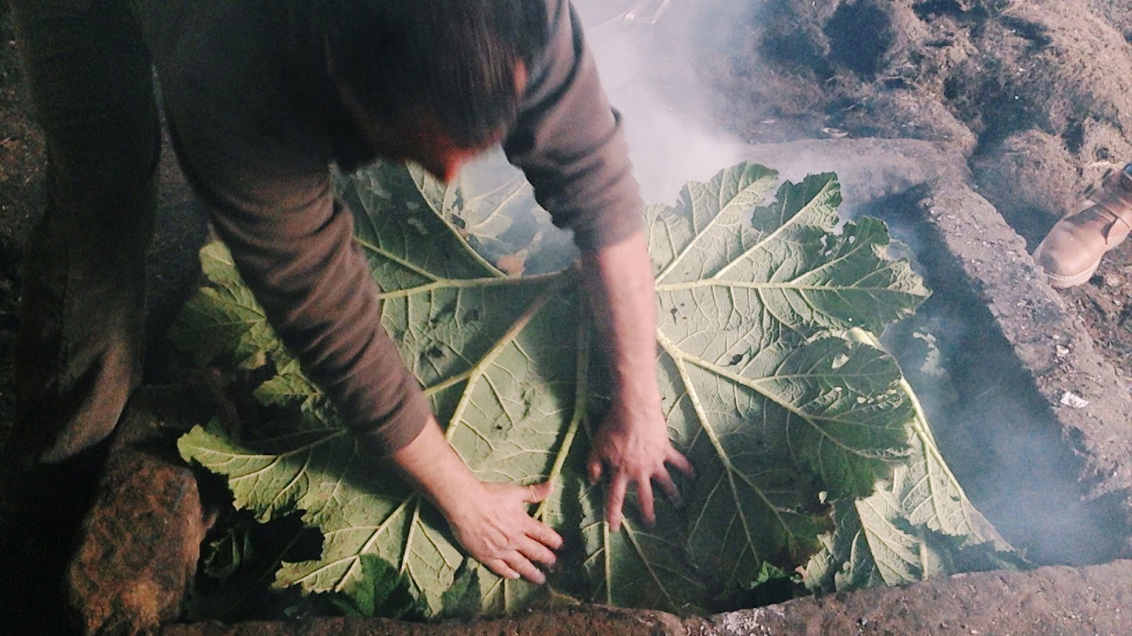
以下圖片請注意用的樹葉為 giant rhubarb 大黃 or Chilean rhubarb:


                                                           Source: https://en.wikipedia.org/wiki/Gunnera_tinctoria

大葉蟻塔(Gunnera manicata),又名巨人大黃(源自英語:Brazilian giant-rhubarb/giant rhubarb),是洋二仙草屬的一種植物,原產於巴西馬爾山脈附近地區。它是一種有著巨大葉子的常綠草本植物,高可達2.5公尺(8.2英尺)至4公尺(13英尺),葉子直徑可達4英尺(120公分),植株整體覆蓋面積達9平方公尺(97平方英尺)。葉子底部和莖上有刺,開紅綠色小花,結的果子也很小。 它可作爲觀賞植物種植,亦曾獲皇家園藝學會金獎,但在寒冷地帶種植的話冬天就會枯萎。雖然又叫做巨人大黃,但它實際和大黃並沒有什麽親緣關係。這是一種極其古老的植物,歷史可追溯至1.5億年前。在其原產地,它會被用來治療性感染疾病。(轉載自維基百科)

--------------------------------------------------------------------------------------------------------------------------------------------------

圖文轉載自: https://munchies.vice.com/en_us/article/pgx8nv/curanto-is-a-chilean-meat-feast-cooked-in-a-dirt-pit

Curanto is a Chilean Meat Feast Cooked in a Dirt Pit


I broke vegetarianism to revel in 'curanto,' a Chilean feast of meats, seafood, and potato dumplings wrapped in leaves and cooked in a fire pit.


Chiloé is an archipelago of lush islands off the southwestern coast of Chile with a history as dense and volatile as its cloud patterns. I am traveling to the north shore of Isla Grande on a mission to try curanto, a traditional dish wherein red meat, seafood, and potatoes are cooked underground in a wood-fire pit coated with leaves. The Lonely Planet calls it "Chiloé's gastronomic bombshell," which, after trying it myself, I will confirm. It is a bombshell, indeed. 

After a weeklong scavenger hunt looking for a person or place that would cook up the stuff, I enlist the help of my hostel staff and land upon a friendly-seeming home restaurant in Ancud: El Meson Chilote. 

Luis Melipichun Avendaño, my soon-to-be culinary spirit guide, greets me one Sunday morning with a firm handshake and a head covered in ash. I catch him in the midst of stage one of the curanto process: firing up the stone-filled pit using flaming chunks of wood. (The word "curanto," after all, translates to "hot rock.")


With impressive speed he extracts the wood, tossing each part into a rusted wheelbarrow—a helpful, albeit inanimate, sous chef. A melange of ingredients are then added to the ditch: nalca leaves, a mountain of mussels, handfuls of clams, and whole potatoes. I ask if I can lend any help. He raises his hands in a quick gesture, revealing calloused, black-pitched palms. I take this for a no.

Within seconds Luis is adding an onslaught of new ingredients: chicken breasts, slabs of pork, and (gasp!) strings of chorizo. His approach is loose, admirably casual, and involves zero utensils or timers. Atop this assemblage of meat and seafood, Luis places a damp towel.


Then come the potato dumplings. Pre-rolled gobs of milcao and chapalele dough—made of potatoes, flour, and water—are plucked from a tray and added to the food heap. Luis pats them down with his bare hands, covering them with another towel. In a snap, he has tugged at the all-encompassing nalca leaves and the whole chabang is wrapped. It looks like a funny vegetal knapsack. It should be noted that this whole process has taken Luis a remarkable one to two minutes to complete—and he is doling out a history lesson about languages spoken on Chiloé all the while.

The last step involves rectangular pieces of tierra—literally, earth—that are thrown onto the pit, trapping any escaping smoke and insulating all the ingredients. The smell is absolutely acrid. If a copywriter were to describe this odor and translate into a marketable scent, it would go something like "Herby Earth Funk" or "Muskier Than Thou Musk."


Reading my mind, Luis asks if I want to step outside for a breath of fresh air. We walk to the lakeside (which is literally 20 steps from the curanto den) to admire the swimming ducks and his neighbors' lumberyards. Live ducks hardly seem like a sight to see after witnessing such diversified animal carnage, but happy with this change of environment and the oxygen upgrade, I indulge.

Luis then serves up some meaty historical bits, which I find as layered and difficult to digest as the meal itself. For the sake of brevity, I direct questions to Luis's background: his father's side is Chono and his mother's is Portuguese. When I ask if he speaks Portuguese though, he laughs, saying that that was too many generation ago to count. Still, he identifies strongly with both sides.


As legend has it, around 5000 BCE, the Chono people—a nomadic group of hunter-gatherers—began practicing curanto. They were highly skilled at hunting seals, fish, and birds, as well as harvesting shellfish. When the Chonos started mixing with the Mapuche people, a new mestizo culture emerged. This mestizo group tilled the land and cultivated potatoes, of which I am told there are 342 different kinds on the Isla Grande alone.
We return to the den, and Luis unpacks the now-charred knapsack, tossing aside its meat-infused leaves.


Since the process of making curanto results in an absurd amount of food, a large group is typically required for the full demonstration. So, the week leading up to this event, I had become a sort of curanto evangelist, trying (usually in vain) to convince other backpackers to join me on this epic culinary adventure. And as testament to my lackluster persuasion skills, the eating buddy I end up with came by his own volition.

After learning that I've been vegetarian for six-odd years and that I was raised in a Jewish family that kept kosher, he starts calling me a curanto-vore. I like this—it absolves me of any moral or religious guilt—and I decide he is a fantastic carnivorous cohort.


We enter the restaurant and within six minutes, the curanto from the ground is translated into curanto on dishes. Magical. Nothing has been mixed together or is even remotely stew-like, which is reassuring.
I start the meal with chicken. It acts like a gateway meat, guiding my way to more unfamiliar terrain. It slips right of the bone and the texture is familiar, which is comforting. With each sliced-off niblet I gain more confidence, and eventually I endeavor into the land of chorizo, pork, clams, and mussels. My partner-in-curanto is gleefully enjoying his pork and glancing at the bounty of shells in front of us.

I am impressed with how well-cooked and not overdone each meat is, considering rocks and leaves were their only heating agents. The pork is chewy, and so salty it's unbelievable that no condiments were added. Its edges are crystallized and give off an appealing glazed sheen. Bones are the real challenge here, and as a novice pork eater I find the task of extracting edible parts quite daunting. A more committed porker might suck meat straight off the bone, but for this formerly kosher eater, several bites are more than enough. (A tide of Jewish guilt hath risen, and is difficult to put at bay.)

Two generous portions of clams and mussels are doled out to us, and if I wasn't overwhelmed before, I certainly am now. But then I discover how fun it is to crack open the shells and dissect their insides. I start pretending I'm Amelie, taking joy in each crack of the creme brulée—err, sea meat—and the contrast of textures is wondrous.

The insides of the clams are charred (which I initially took for its natural coloring.) Surprisingly, I enjoy the mussels most, finding them a light antidote to the other, heartier foods in this dish. The texture of the mussels is almost like a duck pâté.

At first the potatoes—papas nativas—seem unnecessary, but soon I find them to be a much-needed palate cleanser. They effectively balance out the conflicting meat flavors on my tongue, and for this, I am grateful. The potatoes themselves have a storied history—in the 19th century, following the Chilean War of Independence from Spain, there was wide-sweeping poverty and a dramatic flour shortage. To feed their families, Chilota women invented a new bread that required little flour and a plethora of potatoes: hence the birth of chapalele and milcao dumplings.

On my last afternoon in Ancud, I walk to an amazing vista with 360 degree views. To the north, I can make out an ominous-looking gray cloud, which my cohort confirms is the recently-erupted volcano Calbulco. In the other direction I see little trails of smoke billowing out from the countryside. I imagine someone, somewhere, is cooking up a curanto.

---------------------------------------------------------------------------------------------------------------------------

智利希望中国公司参与承建查考跨海大桥

  2012年07月27日  轉載自: http://finance.sina.com.cn/world/20120727/163812691576.shtml
  新华网圣地亚哥7月26日电(记者赵燕燕)智利政府26日表示,希望中国建筑(5.770,0.13,2.30%)公司能够参与修建智利南部奇洛埃岛查考海峡跨海大桥。
  智利公共工程部当天说,中国对修建此类大桥具有丰富的经验和技术优势,他们已向中国建筑公司发出用于投标和建设查考大桥的技术资料。智利公共工程部部长劳伦塞·戈尔沃内不久也将率团前往中国考察类似项目。
  智利公共工程部还表示,用于建设查考大桥的资金将为政府直接投资,国家将支付修建跨海大桥的所有费用,因此大桥建成后的运营不会采取城市公路项目中采取的让渡特许经营权的方式。
  为了纪念智利独立200周年,智利政府计划修建一座横跨查考海峡、连接奇洛埃岛和智利大陆的桥梁,并拟将其命名为“两百周年”,整个项目双向三车道全长2.6公里,总投资约7.4亿美元。
  根据预定计划,2012年8月初将开始第一阶段项目工程设计和施工招标资格预审,然后开始进行工程招标,2014年将最终确定中标公司,2015年中标公司将开始施工,预计工程2019年完工并交付使用。

延伸閱讀:  http://btw001.blog.sohu.com/235976280.html

---------------------------------------------------------------------------------------------------------------------------------

智利媒体关注查考大桥项目


轉載自: http://www.jiaotongjie.com/qs/hot/2014-07-03/12605.html
智利《信使报》6月8日发表评论称,查考大桥项目在拉格斯总统任职期间进行过尝试,但未能成功,经历两届政府后,近期终于开始进行招标。该项目一直有较大争议,目前仍在使用的轮渡方式有效且准时,由于车流量有限,建设大桥后收益率低,项目由政府投资,7.4亿美元的投资项目在当地引起较大关注。

    该招标项目吸引了许多有经验的企业和联合体参加招标,包括来自欧洲、智利韩国和中国的企业。中国企业通常情况下报价有竞争力,技术水平较好,但施工需要自带工人,以适应其要求并有语言便利,但这将与智利的法律相悖。

    由于项目不是特许经营而是政府出资,实际支出成本需要公开。评论对大桥将来不收费提出质疑,以往国家项目同样是收费的。大桥项目投资巨大,使用期要100年,可能成为一个标志性建筑,因此设计必须美观,这一点也当成为选择建设方的考虑因素。
             

2018年11月17日 星期六

法羅群島大湖可供風力抽水蓄能. 2030全綠電


                                              Source: Google map

法羅群島太陽能是欠缺了, 但風力無限.  距離首都托爾斯港Torshavn (地圖右下角) 20公里即有可供抽水蓄能用途之 3.4平方公里大湖  (紅點).  Torshavn 對上10公里亦有湖.  島上風力資源有待開發.  法羅群島計劃 2030 全綠電.

------------------------------------------------------------------------------------------------------------------------

Sørvágsvatn (海上湖)


係法羅群島最大嘅湖泊,位於 Vágar 島上,有 3.4平方公里。人們稱佢為「海上的湖泊」,其最大特色就係佢置身喺懸崖旁,懸崖有 100 米高,因此佢睇上黎好似比起大海高好多!但事實上,呢個係一個奇妙嘅錯覺,湖泊本身只比海洋高 30 米,這完全係相機角度嘅關係!而海上湖嘅盡頭係Bøsdalafossur waterfall(農田谷瀑布)同Trælanípa(奴隸崖)。Trælanípa高148米,相傳維京人以愛爾蘭人做奴隸,佢地會將無工作能力嘅奴隸從奴隸崖推入大海。大家黎法羅絕不能錯過呢個地方呀!Source: https://www.facebook.com/whereisfaroeislands/photos/a.303539593451870/516926185446542/?type=3&theater


Source: https://interestingengineering.com/sorvagsvatn-lake-tricks-optical-illusion


         沃格島上除了上述 Sørvágsvatn (海上湖)外,  隣近亦有一平方公里的第二大湖(下圖紅點).   Fjallavatn is the second largest lake in the Faroe Islands. It is situated on the island of Vágar and its size is 1 km2.    
     
                                                                 Source: Google map


                                                      Source: https://www.google.com/maps

------------------------------------------------------------------------------------------------------------------------------------


Enercon has completed the installation of the 11.7 MW Húsahagi wind farm on the Faroe islands for local utility Elfelagid SEV.
The wind farm near Torshavn on the island of Streymoy consists of 13 of Enercon’s 900 kilowatt E-44 wind turbines for strong winds.
Enercon had already built the Neshagi wind farm with five of the E-44 wind turbines.  Source:  https://www.evwind.es/2014/12/02/enercon-installs-wind-farm-on-the-faroe-islands-with-13-e-44-wind-turbines/49203

愛納康有限公司(Enercon GmbH(德語發音:[ˈEnercon]))是是全球第四大的風力發電機製造商,和自從1990年代中期就是德國最大的製造風力發電機的公司。愛納康在德國(奧里希,埃姆登和馬格德堡),瑞典,巴西,印度,加拿大,土耳其和葡萄牙都有生產設施。2010年6月,愛納康宣布他們將在特拉利建立愛爾蘭總部。 截至2017年12月,愛納康已經安裝了26,300多臺風力發電機組,發電能力超過43 GW。 最常用的型號是E-40,它在1993年開創了無齒輪箱設計。截至2011年7月,Enercon在全球市場份額為7.2%(第五高),在德國市場份額為59.2%。Source: Wikipedia

2018年11月14日 星期三

阿塞拜疆火神庙感受古老拜火文化


2018年11月06日 http://tv.cctv.com/2018/11/06/VIDEMSQcRaUwLiFvycahlWmD181106.shtml

视频简介:阿塞拜疆在阿拉伯语中意为“火的国度”,位于巴库城西侧的火神庙,是17世纪旅居于此的印度人兴建的拜火教寺庙。摄制组走进火神庙,了解古老拜火教文化,感受千年不灭的自燃火。


https://en.wikipedia.org/wiki/Fire_temple


2018年11月13日 星期二

福克蘭群島的排雷專家是津巴布韋人

Source: https://www.apminebanconvention.org/fileadmin/APMBC/MSP/10MSP/10MSP-FinalReport-ch.pdf

Zimbabwean demining expert Farai Beghede at work on a bleak 荒涼 moorland 荒野 in the South Atlantic 
Source:  https://www.bbc.com/news/magazine-39821956


津巴布韋人八年前開始在福克蘭群島每年上工九個月, 共十人左右. 他們對島上資訊科技IT發展落後, 感到可惜, 並評為有如第三世界一樣.  農場主人還是在用傳真機購買零部件和必需品.

島上二千人居住在市中心史丹利港, 其餘800至1000人分散在全島牧場.  十歲兒童便要進寄宿學校讀書, 十歲以下則以電話教學, 或派老師進駐學生家庭.

島民大病往英國就醫, 大學亦在島外自由選擇,  所有費用由福克蘭群島財政支付.  1984年漁場牌費只為四萬英鎊, 其後增至28萬英鎊,  自此開始全島建設行車道.

島上風力資源豐富, 共有六支風車和三套飛輪,節省了35-40%的柴油消耗.  全島85%農場有全日風電供應 https://www.falklands.gov.fk/our-home/renewable-energy


The Falklands penguins that would not explode     7 May 2017    https://www.bbc.com/news/magazine-39821956   @matthewteller

"The mines are horrible things, and very difficult to remove - you essentially have to get on your hands and knees to do that, remove bits of earth and dunes, and disrupt the ecosystem. There's a bit of a trade-off in thinking: what are the benefits of having them removed?" Paul Brickle, director of the South Atlantic Environmental Research Institute, asks.

Initially at least, not everyone in the islands' tiny, close-knit population of 3,000 was supportive.

"Falkland Islanders weren't enthused by the idea, to put it bluntly," says Barry Elsby, a member of the Falklands Legislative Assembly.
"We would rather have left the minefields as they were. They are all clearly marked, clearly fenced. No civilian has ever been injured. We said to the British government, 'Don't spend the money here, go to some other country where they have a much greater need to free up farming land.'"

"Unfortunately," Elsby adds, "the British government have signed up to the Ottawa convention, which puts a duty on them to do this."
The 1997 Ottawa Mine Ban Treaty compels signatories - which include the UK - to clear minefields in territory under their control.
So whatever the locals - and the penguins - thought, the mines had to go. 

Since 2009 the British government has spent tens of millions of pounds on mine-clearance in the Falklands. Guy Marot of the Falkland Islands Demining Programme Office oversees a team of largely Zimbabwean operatives, highly valued for their long experience of demining in their home country and further afield.

He takes me out to one of the clearance sites. In a setting of wide open moorland, battling gales and driving rain, demining specialist Innocent Mudzamiri, fully kitted out with protective clothing and visor, explains how he approaches his job, lying prone 俯臥 in the boggy 湿软的  peat, painstakingly clearing dirt from around devices that could blow up in his face.

"It's just caution. You have to do it gently, so that you don't disturb the mine," he says.

"Your mind must be free - no thinking of home, or thinking whatever, but just concentrate."

So far, Mudzamiri and his colleagues have cleared more than seven million square metres of mostly rough countryside. But now, Phase 5 of the demining programme is seeing sensitive sites of environmental concern, such as Yorke Bay, come up for clearance.

The Falkland Islands Government is part of the way through drawing up an environmental impact assessment, examining the risks and benefits from demining wildlife-rich sites.

Yorke Bay is particularly difficult, since in 1982 mines were placed on top of the sand dunes, but, over 35 years, the dunes have changed shape and shifted with the wind. Even with the detailed charts handed over by Argentina to the UK after the war, it's impossible now to know where the mines might be - they could have drifted far from their original position or become buried deep below the surface.

The deminers are facing having to dig up the entire beach, perhaps with armoured machinery, and sift it all. The idea is to do that during the winter, while the penguins are out at sea. But their habitat, and the wider ecosystem, could be entirely destroyed.
Another potential hazard is tourism, a key driver of the Falklands economy. About 50,000 people visit the islands annually, most of them day-trippers from cruise ships plying 定期往返 the waters around South America and Antarctica.

Each time a cruise ship docks, hundreds of passengers at a time come ashore to see the wildlife. If Yorke Bay is reopened, its easy-to-reach location - barely 10 minutes' drive from Stanley - could make it a magnet for tourist traffic.

Another source of worry comes from the locals. Most beaches in the Falklands are on private land. But Yorke Bay is publicly owned - and opening it up could revive its pre-war status as one of Stanley's most popular getaways. There are already concerns about quad-biking 四輪機車 and livestock grazing 放牧 on public land outside the Yorke Bay fences. Whether the rejuvenated land within the minefield could be protected when the fences come down remains uncertain.

In 2010 Marot oversaw the clearance of Surf Bay, another beach near Stanley, which held 1,800 mines. Today, as locals ramble 漫步 over dunes and on to its sandy beach to walk their dogs, it's hard to discern the damage that was done.

"The re-establishment is remarkable," says Marot. "The processes used at the time included blowing up the anti-tank mines in situ 在原本位置. The holes here were 10m deep in some places - this was a moonscape 月的表面. But then we put all the sand back on top, and tried to do it in a way that would allow nature to eventually recover completely, which is what you see now."

So the Falklands is facing a head-on clash between the obligation to clear mines and the imperative for environmental conservation.

Meanwhile the honking 鵝鳴叫 jackasses  鳥 behind the Yorke Bay fences are thriving, ironically because of one of the worst things humanity can do - start a war.

延伸閱讀:  http://minekafon.org
                                 
                                   http://en.mercopress.com/2016/02/24/falkland-s-demining-project-fourth-phase-draws-to-a-close